Location:-
Kodagu district lies between 11056’ and 12057’ North latitude and 75022’ and 76012’ East Longitude.
Length:-
96 kms from Brahmagiri Hills in the south to the Hemavathi River in the north.
Width:-
64 kms from sampaje in the west to kushalnagar in the east.
Altitude:-
1,166 Meters above sea level.
Temperature:-
|
Season |
Maximum |
Minimum |
|
Summer |
30c |
20c |
|
Winter |
28c |
16c |
|
Monsoon |
june to september. |
|
|
Forests |
32.76% of total area. |
|
|
Rainfall |
2700mm |
|
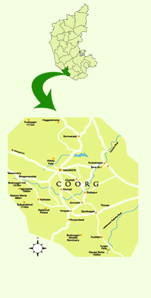
Rivers:-
Cauvery, the lifeline of kodagu. its source high up amidst the Western Ghats at Tala Cauvery. The River Cauvery also known as ‘Dakshina Ganga’ forms a natural boundary between Mysore and Kodagu districts. Other rivers are Harangi, Hemavathi, Barapole, Lakshmana Theertha and Kumaradhara.
Protected Area:-
- Rajeev Gandhi National Park, Nagarahole: 643 sq kms
- Tala Cauvery Wildlife Sanctuary: 105.00 sq kms.
- Pushpagiri Wildlife Sanctuary: 102.59 sq kms
- Brahmagiri Wildlife sanctuary: 181.29 sq kms
Fanuistic Diversity:-
Asian Elephant, Tiger, Panther, Indian gaur, Leopard, Sambar, Four Horned Antelope, Spotted dear, Mouse dear, Leopard Cat, Small Indian Civet, Clawless Other, Common Giant Flying, Squirrel, Flying Fox etc. are some of the important ones. 350 species of birds and thousand of insect species, 25 varieties of snakes including Cobras, vipers and Kraits.